Madagascar to Richards Bay: The routes and the formalities
Bev and Robbie Collins on their 46ft yacht Mersoleil had an interesting passage from Madagascar to Richards Bay. Whilst the sailing presented a few challenges the formalities on arrival were a test of their resilience.
Published 6 years ago, updated 5 years ago


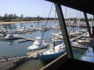
- Tuzi Gazi Marina, Richards Bay, courtesy of www.tuzigazi.net
The route options
Cruisers making the passage from Madagascar to Cape Town must decide where to hop across the Mozambique Channel. The popular choice is to depart Madagascar at Cap de Ste Andre (16 06S), sail straight across the Channel to the East Coast of Mozambique, and then begin making one’s way down the coast to Bazaruto (21 29S) where the first suitable anchorage with protection from southerly winds is located. From Bazaruto, a number of carefully timed hops are required to cover the remaining 550nm to Richards Bay.
We chose instead to sail another 340nm down the sheltered and relatively easy west coast of Madagascar to Morombe (21° 43’S) before jumping across the Channel and running directly to Richards Bay. It was an excellent choice for us, but a choice we can only recommend to cruisers supported by the services of a professional meteorologist/weather router, and we sailed from Morombe straight to Richards Bay, South Africa, in 5 days 6 hours. (Fuel by jerry can and wet market provisions are available in Morombe, by the way. Land your dinghy on the sand beach.)
Arriving at Richards Bay
Upon arrival at Richards Bay, all vessels must call Richards Bay Port Control when they reach the six-mile line from the channel entrance. Port Control does not respond to radio calls before 6 am local. After the workday commences Port Control is watching you on AIS and your call 6.5nm from the channel will fall upon deaf ears. We arrived about 36 hours before a predicted southwesterly change and the port was in a frenzy with ships arriving at anchor near shore. The charts and all we have read caution that ships enter the narrow channel in a scheduled and controlled order and that we should not expect immediate permission to enter.
We were loathed to arrive at the channel without permission and blow past at 9.5kts, which was the speed generated by our heavily reefed main, 25-30kts of NE wind and whatever push was left in the tattered edge of the Agulhas Current. As we approached the coast, I hailed the port to ask if we needed to stand off, and was rebuffed with, “You are calling too soon.” Now we know the answer to this plight is simple. Keep going. Once they were on speaking terms with us (within 6nm), Port Control instructed us to proceed directly into the 300m wide channel.
“Don’t worry, I am watching you and I will guide you where to go,” said the Port Control radio officer. Except he didn’t. He was busy with ships calling in and he must have stepped away from his desk for a coffee every few minutes, so we felt quite lost once inside the channel. Winds inside the channel continued to howl at 25kts and we still needed to get out dock lines and fenders, which had been stowed for the rough passage.
Port Control’s instructions for reaching the “Tuzi Gazi International Wall” were totally incomprehensible to us. This waypoint will be more helpful than anything you will hear on your VHF: 28° 47’ 694” S 032° 04’ 697” E. It identifies the “International Wall,” a rough concrete wharf 4-6m high depending on tide level, with steel ladders up to ground level. It is impossible to tie to this wall without the assistance of at least one line handler standing above, which was promised by Port Control but never materialized. We made three attempts at the International Wall before giving up and tying unauthorized to a nearby floating pontoon owned by Tuzi Gazi Marina, for which action we were roundly criticized and told by someone at Tuzi Gazi that we may be fined. In fact, no fine was ever suggested by any of the authorities. The Tuzi Gazi pontoons are unsuitable for boats larger than about 36′. Mer Soleil is 46′ and we tied up anyway, grateful to get away an hour later without demolishing their little dock.
The Formalities
The official protocol is that the yachtsman must ask Port Control to please arrange for the authorities to be sent to his vessel to complete the check-in formalities. They know this, but if you don’t know it and don’t ask, nothing will happen. Port Control sent an Immigration officer to us. She was lovely, and friendly, and wanted nothing but passports and a crew list.
It is also necessary to see the Police, Customs and the Port Captain and Health.
Here’s how we accomplished each:
The Port Captain.
We asked how and where to find the Port Captain and were told, “Did you speak with Port Control on VHF?” Yes. “Did they take the name of your vessel, nationality and number of POB?” Yes. “Then you have checked in with the Port Captain.”
Police.
Three Port Police officers arrived on the dock at Tuzi Gazi just as we were preparing to leave. They took a few details all of which we gave from memory, they looked at our passports, and very generously slipped the lines for us as we backed away from the dock. We could have done this later in town and it would have been fine.
Customs.
Robbie visited the Customs building in town on the next day following instructions on a map provided by the helpful staff at Zululand Yacht Club. Easy. Friendly. No problem.
Health.
Maybe there’s a Health Department, but we haven’t seen one, nor have we heard the further suggestion that we ought to pay them a visit. Everyone, all the officials, that is, seems to ignore this ‘requirement’ and so did we.
No one asked for payment of fees of any kind.
The Yacht Club
As far as we know Zululand Yacht Club is the only reasonable place to stay while in Richards Bay. Fiona, the Admin Manager, is smart, knowledgeable and very helpful. The club offers a bar, a casual restaurant serving breakfast, lunch and dinner, ATM, laundry, showers, boatyard and chandlery all on the premises. Taxis are readily available for errands to town. It’s an active yacht club known to extend a friendly welcome to foreign yachts and, in general, a pleasant place to rest up and have some fun after a tough passage.
N. B. If preparing to dock at the very low pontoons at ZYC, lower your fenders all the way to the water.
Fiona suggested that we hang onto the maps she gave us showing the exact locations of Customs and Immigration for use when we leave. Perhaps that means we will check in and out of ports as we work our way to Cape Town, but it’s too early for us to say.
Bev and Robbie Collins
sy Marsoleil
Related to following destinations: Cape Town (Table Bay), Madagascar, Richards Bay, South Africa
Related to the following Cruising Resources: Indian Ocean, Routing


