
Fiji to Lombok, Indonesia: A 3800NM Non-Stop Journey
On August 20, 2021 Jörg Domann and his crew member Jakub set sail from Fiji on a near 4000NM non-stop journey to the island of Lombok in Indonesia. Along the way they encountered heavy seas, strong winds, drift nets and the most turquoise coloured sea they had seen in their travels. Here is an extract from their story.
Published 3 years ago
On August 30th, 2021, I set off for Lombok, Indonesia with my crew member Jakub. It was unclear whether we would be allowed to make a stop on the route. We also didn’t have visas for Indonesia, but the cyclone season clock was ticking relentlessly and it was time to leave Port Denarau and Fiji.
FINAL PREPARATIONS:
Route planning
There are almost 4,000 nautical miles ahead of us without going ashore. If Indonesia does not open within the four weeks and does not approve our visa applications, we will go straight to the Maldives. This extends the total distance of our voyage to over 6,500 NM. In contrast to my first Pacific crossing from Costa Rica to Nuku Hiva, we will pass several countries and groups of islands. Route planning is therefore one of our most important preparations.
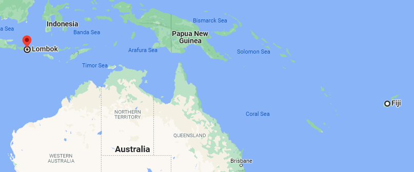
- Nearly 4000NM between Fiji and Lombok.
Vanuatu
First, we pass Vanuatu. Unfortunately, the request for approval for an anchor break remained unanswered, so I just looked for the best emergency port (should we need it). We will probably only see the next country another 1,500 NM later when we reach the Great Barrier Reef.
Australia
For the entrance to the Great Barrier Reef, I have chosen four entrances. Which of these we ultimately use depends on the weather. Raine Island Entrance would be ideal. It offers the shortest route. From there it goes into the Torres Strait, which according to my definition separates the Pacific Ocean from the Indian Ocean. At the narrowest point, above Thursday Island, dense traffic awaits us on narrow waterways, strong currents of up to 8 knots and a choppy sea if the wind and current are in opposite directions.
For a few weeks now I have been looking regularly at the weather report for these 250 NM. I was able to make an important observation. The low-pressure areas, which passed the Fiji Islands south of Australia every 14 days at least during the observation period, have a strong influence on the weather situation in the Torres Strait. On 8-10 days there is a strong south-east trade wind at its entrance, which can sometimes reach 30 knots in gusts. It pushes the Pacific into the strait with waves up to 4 meters. For the remaining 4 to 6 days, wind and swell are moderate. I would like to use this time window. In return I gladly accept that it can get a little windier on the way there.
Indian Ocean
After the Torres Strait our route goes about 600 NM to the west in the shallow Arafura Sea. Cape Wessel offers itself as a recovery stop and Darwin as an emergency stop. Then we have to decide whether we should accept higher waves for the stronger winds south of Timor or sail the remaining 700 NM through the Flores Sea. It’s still too early for that now.
After passing Lombok we have to head a little south to catch a stable SE trade wind, which is then called monsoon. It should carry us as far west as possible. South-southwest of the Chagos Islands we would then sail the last 600 nautical miles north to the southernmost port of entry in the Maldives. But for now we are hoping for a longer stay in Indonesia.
Last Minute Maintenance
We spent an unplanned whole day cleaning the sewage hoses that were completely calcified after six years. The first leaks in the electric sewage pump were revealed. I would like to spare you further details of this nightmare at this point. After a thorough inspection, I got some replacement materials that could be helpful for the remaining route to Europe. Based on the experience of other sailors, I stocked up on my spare parts with hoses, hose clamps and glue.
Provisioning
After the compulsory inventory of the food on board, which still comprised around 100 daily rations, we made a shopping list and went to the exceptionally well-stocked supermarket on the edge of the Blue Lane Zone in Port Denarau. We got fresh fruits and vegetables delivered to us by Farm Boy, who had transformed his business into a delivery service due to the covid situation in Denarau.
With that the preparations were completed. Ready to go!
- Goodbye Fiji.
Departure – Covid-Test and a Good-Bye-Burger
The day of departure, August 30th 2021, began with a trip to get a covid test. It wouldn’t be necessary for the Maldives, but since we do not know exactly where we end up with which set of rules, we cannot avoid spending several hundred euros on this. At the same time, the end of the Fiji period ends. With the doctor visits outside the Blue Lane Zone, our permission to move between the islands will expire. Back in the marina we treated ourselves to one last burger at Sheetal. Then the time came to cast off and head out through the Malolo Passage. As the sun disappeared behind the horizon the lights from Fiji Island became noticeably smaller.
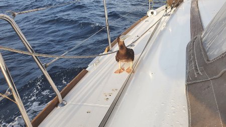
- A Brown Booby takes refuge on Aurelia’s deck.
Vanuatu
Thanks to an average speed of 5.5 knots, the journey to Vanuatu is quick. First, we had to get used to the cold nights. The open sea and occasional rain and tiredness made us quickly get the warm clothes out of the closet. Even the oilskins weren’t enough, I had to wear a leisure suit underneath. What is it going to happen when we sail back into cooler climes?
The gusty wind from the south not only gave us a record Etmal of 154 NM (Etmal is a common word used in Germany to describe the distance achieved within 24 hours), it also pushed us a little more north than initially planned. So we passed the archipelago north of Efate. The weather got better and better. Our solar system provided us with plenty of electricity. The autopilot and the on-board instruments could be supplied without any problems. In addition, it was sufficient for excessive cooking and for the water maker.
We reached Vanuatu in the early morning of September 3rd. So we could pass the islands in daylight in their lee, we had to switch on the engine for the first time since Fiji. After only two hours the wind returned.
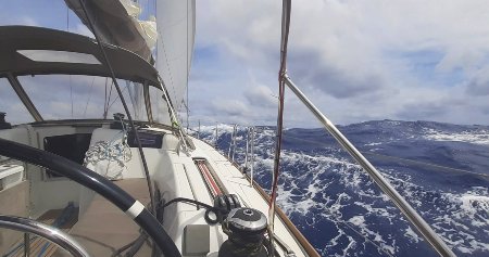
- Stormy conditions at sea.
The last 1,500 NM in the open Pacific
The next section with a length of 1500 nautical miles had some surprises in store for us. It started with moderate winds and sunshine and an average speed of 5 knots – “champagne sailing”.
Soon, however, the calm came to an end. The weather forecast predicted gusts of up to 38 knots. So on September 7th we prepared for storm winds. Dinghy engine, code 0 and other unnecessary items were removed from the cockpit and fore deck. We also positioned long lines at the stern in such a way that we could deploy them easily. We packed the main sail into the lazy bag. We reefed the genoa so far that only a few square meters were left for propulsion. Now that the birds have also sought refuge on the Aurelia, the bad weather cannot be far away.
After three days the weather began to improve and the swell decreased slowly but steadily.
On the remaining 500 nautical miles to Australia, we used the code 0 more frequently in winds of up to 16 knots. When the connection between the sail and the furler broke 200 nautical miles from the Great Barrier Reef, we furled it away and sailed mainly with the genoa.
The 2nd time change and changing the Pacific chart for the Australian one, were two positive milestones after some stressful days.
Great Barrier Reef
On the evening of September 14th, we were only about 40 nautical miles from the Raine Island Entrance. The swell was only a moderate two meters. The extrapolation of the tide showed that during my shift we will pass the entrance quite precisely at the high water slack tide. Perfect! That’s how I imagined it and calculated it. We passed the entrance at night without the slightest problem from the current or the swell. However, there was no trace of land the next morning either. All the areas shown on the map, some of which were falling dry, were under water.
Australia Border Force Greeting!
Not surprisingly, we were greeted by an Australian Border Force (ABF) aircraft. With no perceptible sound, it descended from our bow with the propellers nearly idling. Only at the last moment was a faint engine noise to be heard as just above the mast, it revved up the engines. The plane disappeared after a few seconds behind the stern. After a few more seconds, the aircraft reported on the radio with a crystal-clear announcement: “To the white sailing vessel, which was just overflown by an ABF aircraft.”
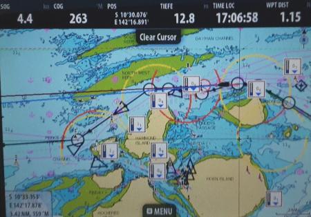
- Navigating the Torres Strait.
Torres Strait
At around 2:00 a.m. we were just before the entrance to the Prince of Wales Canal. Unfortunately, I wasn’t the only one waiting for the perfect moment. Three vessels with a length of approx. 300 meters wanted to pass it at the same time. After some radio communication it was clear to everyone what position the other vessels were taking. Then we went into the canal. At first I stayed as far west as possible so that the tanker coming from the south could overtake us on our starboard side. Shortly after passing the freighter coming in east, I entered the Prince Of Wales Canal and drove so close to the north side that I had the feeling that I could touch the eight meter high mast of the beacon there with my hand.
In fact, we were still 90 meters away. Finally, the tanker approaching from the west passed us without any problems. We passed the narrowest point exactly at the flood time. We were through! No counter-current, no choppy sea. The rest is “just” sailing in a confined space. Jakub had supported me all the time with binoculars and checked with bearings whether we were on a collision course with one of the navigation signs or vessels. I’m glad I didn’t have to go through here alone. I would only have done that during the daytime.
Exhausted and happy about the successful last 48 hours, I disappeared into my bunk. I was so tired that I even forgot that I sleep in the salon at sea.
- The Arafura Sea is only about 50 meters deep in the east. The sea shimmers turquoise to the horizon.
Arafura Sea
Still happy about the successful passage of the Great Barrier Reef and the Torres Strait, we considered whether we should call at the intended anchorage in Cape Wessel or sail non-stop to Lombok. Since the freshly fetched weather forecast predicted a large-scale and long-lasting lull, the decision was an easy one – we would go directly to Lombok.
We took a much more northerly course through the Arafura Sea and through the Merkara shallows. We crossed the approximately one Kilometer wide area almost in the middle. Fortunately, it was sufficiently deep at 6 meters. Otherwise, I would probably have noticed it earlier. However, I only discovered them after arriving in Lombok.
Over the next few days the wind was blowing at 16 to 20 knots in almost ideal strength and direction. Only on the first and second day there were gusts of up to 27 knots. The Aurelia rewarded this with an average speed of almost 6 knots for days.
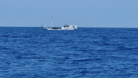
- Fishing boats but thankfully no pirates.
Illegal driftnet?
On the first night we had an unusual encounter. In the middle of my night shift, numerous AIS signals suddenly appeared. They were not marked as buoys, but as vessels with constantly changing directions. The vessel names also changed. Voltage and level information was coded into them. I tried in vain to make radio contact. Since the signals came from all directions and did not reveal any pattern, I was unable to make a meaningful decision to change course.
At dawn it happened: a few meters from the Aurelia, a fishing net appeared just below the surface of the water. The top line was at least as thick as a thumb. Every 30 cm it was provided with a fluorescent float. It was far too late to evade. There was only time to strive for a right angle to the network, then I already felt a delay. We hit this extremely stable net with our keel. Slowly it rolled lower and snapped backwards after it passed its lower edge.
We are now probably within a gigantic driftnet of unknown origin. The process was repeated an hour later. We have evidently escaped the net again. After the encounter with the driftnet, I was glad that we came into the Australian economic zone again. The risk of encountering illegal fishing is significantly lower here. Another ABF plane visited us. It flew low over us twice.
Course decision: North or South
On the night of September 21, we came pretty close to the first Indonesian island of Yamdena. The next day we had to decide: do we sail north into the well-protected Flores Sea or do we make a southerly course around Timor and head for Lombok from below? According to the weather report, we expect weak winds in both areas. In the Flores Sea, however, much later. We may then be within engine range of Lombok. So I decided on this route.
Just 24 hours later we found ourselves in the Flores Sea. Wind, currents and swell gave us a good Etmal of 140 NM during the entry. Now we passed one island after the other. Almost alone on the sea during the day, we encountered numerous fishing boats at night. Most of them had AIS and had correct lighting. Unfortunately not all of them.
On the morning of September 25th, we caught the first doldrum. There are still more than 500 nautical miles to Lombok. Too far to reach our destination with the engine. By and large, however, our plan worked out. We had decided on the right route with the Flores Sea.
With frequent changes between sailing and engine operation, we fought our way west. On September 29th at 10:30 am I discovered the land of Lombok for the first time. The 3700 meter high Rinjani volcano showed its peak above the clouds. That is amazing, there are still 100 nautical miles to the destination.
After more than four weeks at sea, our anticipation for the arrival increased by the hour. However, we still had to concentrate on the journey. Not every vessel has AIS. The smaller ones are sometimes without and at night without lights. In addition, the rubbish and debris in the sea was constantly increasing.
In the afternoon I mentioned to Jakub that the next 24 hours can be exhausting again. According to the weather report, gusts of up to 25 knots are expected north of the Lombok Strait. Since we are sailing south-west first and then straight south, this means beating over the last 50 miles. In addition, there is dense traffic, currents running against the wind and shallows.
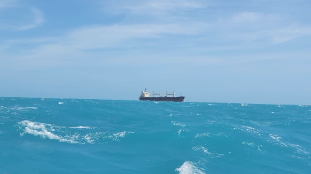
The reality was much better, however. We motored all night with little wind. More and more freighters and tankers appeared on the plotter. Like a string of pearls, they passed through Lombok Street. Only at dawn did the wind pick up. We set sail and sailed upwind between land and waterway towards our goal.
As the sun rose higher, small sailing boats began to appear more and more frequently. In total there were over 50 of these boats that crossed our course. Most of the time I was behind the wheel while Jakub kept an eye out with the binoculars to see if we had a stationary bearing for one of the boats and were thus on a collision course. Several times I had to evade and make one or two additional turns. Even if we were a little exhausted after the long tour, I had a lot of fun on this final spurt.
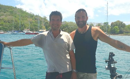
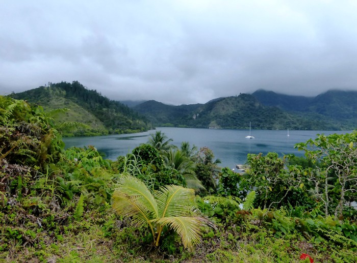
- Jörg (left) and Jakub after arriving in Lombok, Indonesia.
Arrival
We hid the sails three miles from the marina, closed the lazy-bag and prepared to tie on a mooring buoy. We had to be careful one last time. Between the hard-to-see blue buoys of the fishing nets and the still numerous Jukungs, there was little room for the Aurelia.
At 1:30 p.m., after 3,836 nautical miles, 4 weeks, 3 days and 4 hours, we tied to a free buoy. More relieved than exhausted, we treated ourselves to a first berthing cocktail.
Jörg Domann
SY Aurelia
………………………………………………………………………………………………………………………………………
About the Author:
German-born Jörg Domann worked as a computer developer and management consultant before falling in love with sailing. After more than 12 years of experience sailing the Mediterranean, Caribbean and the Indian Ocean he embarked on a new adventure to sail around the world.
This is an edited version of his full report on the journey from Fiji to Indonesia, which can be read on SY Aurelia’s Blog – https://sailingaurelia.de
………………………………………………………………………………………………………………………………………
The opinions expressed in this article are the author’s own and do not reflect the view of Noonsite.com or World Cruising Club.
………………………………………………………………………………………………………………………………………
Related to following destinations: Australia, Fiji, Indonesia, Port Denarau, South / Central Indonesia - Lombok, Vanuatu, Viti Levu
Related to the following Cruising Resources: Circumnavigation, Circumnavigation, Indian Ocean, Pacific Crossing, Routing, Timor Sea


An excellent read–thanks for posting!
We made the passage from Fiji to Lombok a little later. Indonesia stopped issuing visas for six weeks and once we obtained ours we cleared out of Vuda Marina on October 6th and arrived at Marina del Ray on Friday 5th November. We took the southern route after the Torres Strait. No problems with the passage those started in Indonesia. Albert the manager/agent at Marina del Ray who had sponsored our visas waited until we arrived to inform us that Lombok was no longer a clearance port and that we would have to go onto Bali to clear in. We arrived in Benoa harbor on Sunday evening and had no luck raising the marina on VHF and anchored safely in the harbor thanks to a helpful charter boat skipper. The agent we had been passed onto by Albert proved to be of no help in getting the port health officials to start our clearance as she said we were not on the list of nationalities (one Irish and one US citizen) that could enter Bali under the new regulations. We waited on anchor, Q flag flying, and were offered the services of another agency PT. Trans Cakrawala Perkasa by one of their staff, Permahadi (+6281337321017). We sat on anchor, contacted our respective consuls and embassies, and waited. Friday afternoon Permahdi came through for us and arrived with the port health officials to start the clearance process. They were quickly followed by customs. Immigration stamped us in without even seeing us, accepted our agents representation.
All should have been completed after a weeks uncertainty and waiting but no, the port health authorities insisted that we follow the current fly in visitors protocol and we had to move off the boat the next day to be transported to an approved quarantine hotel for three days and two PCR tests.
The good news is that today the 16th November we are fully cleared into Indonesia, eleven days after arriving and paying two clearance agents, hotel and tests.
Mark Norman
S.V. En Passant