Kavieng - General Info
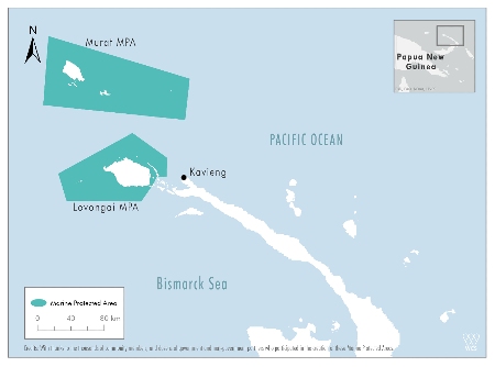
Where is Kavieng?
Kavieng is the main port on New Ireland and is a Port of Entry for Papua New Guinea. The harbour is formed by three connecting islands and is very sheltered from the west and the east, but is exposed in northerly and southerly winds.
Kavieng Cruiser Highlights:
Gas, diesel, LPG refills, and provisions are available here. For yachts heading north for FSM, Palau, or points north, or coming south from FSM, Kavieng is a useful provisioning and refueling stop.
Kavieng is an excellent place for clearing into PNG and if you have any issues with your engine or fridge, there are people here who can help. Prices tend to be high however as most goods are shipped from Australia.
Kavieng Restrictions:
Papua New Guinea has announced two new Marine Protected Areas (MPAs) covering more than 1.5 million hectares in the New Ireland Province, in a major conservation effort for critically endangered sharks, rays, and turtles. The MPAs are in Lovongai and Murat Local Level Government (LLG) jurisdictions in New Ireland Province.
The Murat MPA includes full protection for marine turtles, dugongs, whales, dolphins, and (in five of the six wards) all other shark and ray species. If you are planning to sail to these areas, please check with local authorities on what you can and can’t do in these new areas.
See the following news item for more information.


Position:
02° 35.11’S, 150° 46.91’E (safe anchorage)
Last updated: March 2024
Read and Post Related Comments
If you have information for this section, or feedback on businesses used, please let us know at editor@noonsite.com. We also welcome new information about businesses you have used (see Related Businesses).
Next Section: Profile: Clearance
Related to following destinations: Kavieng, New Ireland, Papua New Guinea
Port Navigation
Courtesy Flag Discounts


YachtFlags.com provides high quality courtesy flags that are manufactured in durable Knitted Polyester fabric. Knitted so that the fabric itself does not deteriorate in the constant movement that marine flags are usually exposed to, and polyester so that the flag does not weaken in the strong UV-light usually found in the main sailing areas of the world.
YachtFlags.com offers a discount to Noonsite members.
Use the coupon code NOONSITE_5A2B when checking out to get 10% off today.
Buy Now On YachtFlags.comMain Ports - Papua New Guinea
Courtesy Flag Discounts


YachtFlags.com provides high quality courtesy flags that are manufactured in durable Knitted Polyester fabric. Knitted so that the fabric itself does not deteriorate in the constant movement that marine flags are usually exposed to, and polyester so that the flag does not weaken in the strong UV-light usually found in the main sailing areas of the world.
YachtFlags.com offers a discount to Noonsite members.
Use the coupon code NOONSITE_5A2B when checking out to get 10% off today.
Buy Now On YachtFlags.com


Posted on behalf of Andrew of SY Yawana:
I was in Kavieng & New Hanover on Dec 15 – to Feb. 16 and enjoyed my time there very much. Kavieng is a friendly town, no real security issues and an excellent anchorage in front of the Nusalik resort. Clearing in was a simple affair after my experiences in Indonesia.
The villagers on Nusalik island where the resort is located were very friendly and keen to encourage yachts to visit. I stayed at the resort a few nights and they provided a boy to sleep on my boat at night as additional security.
The banks in Kavieng are BSP and Westpac and they both have ATMs. There are numerous trade stores that are well stocked but quite expensive as most goods are shipped up from Australia. Fuel is easily purchased from the depot or can be arranged through the Nusa Resort. Freshwater may be a problem during the dry months.
Posted on behalf of Graeme Ward:
Some information on Emirau Island – 70nm NW of Kavieng. Great welcoming village, happy to have yachts, no shops, very willing to trade. Secure anchorage except in a strong Southerly. Anchor between Emirau Island and Elomusao Island in about 10m.
The passage to the North is not navigable and beware of a reef in the centre of the pass in from the South. Keep closer to the main island. Navionics and C Map charts are out by about 1nm+.
There is an old WW2 base in the North, although we never went there.
Rather remote, one tale the locals told us, was of 3 fishermen who were lost at sea for 3 and 1/2 months – 2 survived and were picked up at the Gilbert Islands!