
Weather: NOAA Plans to Remove Florida Weather Stations
NOAA/National Weather Service is seeking public comment on its plans to “disestablish” the automated weather stations at both Molasses Reef (on the Florida Reef tract off Key Largo) and Pulaski Shoal (in Dry Tortugas National Park).
Published 2 years ago
Source: Seven Seas Cruising Association
Weather and ocean data have been collected routinely for years at both Molasses Reef (on the Florida Reef tract off Key Largo – since the mid-1980s) and Pulaski Shoal (in Dry Tortugas National Park – since the early 1990s).
In commenting on the proposed closures, Joan Conover, President of Seven Seas Cruising Association(SSCA) and a long time cruiser off the Eastern USA, recognized the excellent weather support provided for boaters by NOAA, but queries the proposed changes.
“The USA NOAA buoy systems support our knowledge of wind/sea conditions along the southern Florida Keys/Gulf Stream. This is extremely important information for small vessels. However, after reviewing NOAA’s request for comment on the proposed closure, we suggest that at least Molasses Reef be kept active. These buoys are also part of the of many published cruising guides and Electronic Navigation Charts and change takes time with printed publications or charts.”
Joan goes on to explain; “Cruisers heading to Bahamas or back from Bahamas, or coming up the Old Bahama Channel from points to the east/west, utilize these buoys. We know in our passages, this is set in our navigation/email systems as a point to query. What will provide the same data the two buoys currently provide? Will boaters be able to query other buoys to provide the same local details? And if so which ones?
“Molasses Reef and Pulaski Shoal both are a ‘early warning system’ for small boats. We know from personal experience, we monitor those buoys and a sudden change in wind direction to even sightly north in the Gulf Stream can be, if not deadly, certainly a very rough ride. We sail a 51 foot offshore sailboat transatlantic, and one of the most difficult areas of water to cross or enter is the Gulf Stream. Since crossing is about 50 miles, the timing is critical; a slight northerly component can raise seas rapidly from one or two feet to nine+ feet or more of uncomfortable steep and close period waves in a short time. Small vessels have difficulty in these types of conditions.”
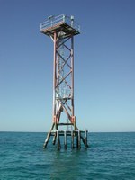
- PLSF1-Pulaski Shoals Light, FL
The official NOAA “Service Change Notices” are linked below:
https://www.weather.gov/media/notification/pdf_2023_24/scn23-05_ndbc_mlrf1.pdf
https://www.weather.gov/media/notification/pdf_2023_24/scn23-06_ndbc_plsf1.pdf
There is a 30-day public comment period for each notice, ending on February 21, 2023. Both stations are scheduled for “disestablishment” on February 28, 2023. Anyone wishing to provide comment, as per the Service Change Notices, can contact:
Dr. William Burnett
Director, NOAA/NWS/National Data Buoy Center
E-mail: william.h.burnett@noaa.gov
Related to the following Cruising Resources: Forecast Services, Weather


The correct URL for the notice regarding Molasses reef is:
https://www.weather.gov/media/notification/pdf_2023_24/scn23-05_ndbc_mlfr1.pdf
Thankyou! We’ve updated.