
South Pacific: Dangerous weather warning for subtropical waters north of NZ
Yachts currently en route to or from the tropics in or out of any port on the north island of New Zealand should be aware that there is dangerous weather and hurricane force winds forecast for subtropical waters northeast of Cape Reinga to the north of NZ.
Published 2 months ago
Most Severe Weather Expected to Be Offshore
Updated: Saturday July 20, 2024 – source: www.weatherwatch.co.nz
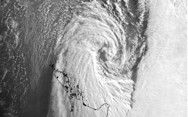
The storm formed rapidly and is being described as a ‘weather bomb’ (technical name: bombogenesis, or explosive cyclogenesis), according to a New Zealand weather website. This is when a low pressure system drops more than 24 hectoPascals in 24 hours. In simple speak: The air pressure drops fast and a storm forms within a day.
However, forecasters at WeatherWatch said there was a high chance that most of the severe weather will be offshore, but some might brush the north-eastern North Island and the upper North Island.
John Martin from Sail South Pacific told Noonsite he had several boats waiting out the storm and hoping for a good weather window for departure soon.
“Boats have required significantly more patience weather-wise when heading to the Pacific Islands this season,” John said.
Weather Warning for Yachts
Earlier in the week, Port Denarau Marina, Fiji, shared the following weather warning for yachts currently en route to or from the tropics in or out of any port on the north island of New Zealand.
Courtesy of Nadraki Weather.
The following images are a sequence of model forecast graphics from Windy TY showing the forecast weather pattern from the ECMWF 9km global model (issued around 6pm this evening) beginning Thursday at midnight and ending Saturday at midnight. The last three show the pattern at 12 hourly intervals – midnight Friday night, noon on Saturday, and midnight Saturday.

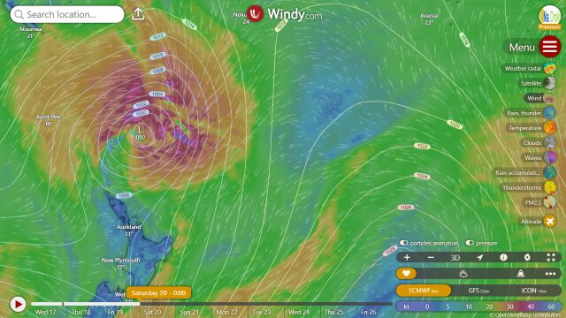
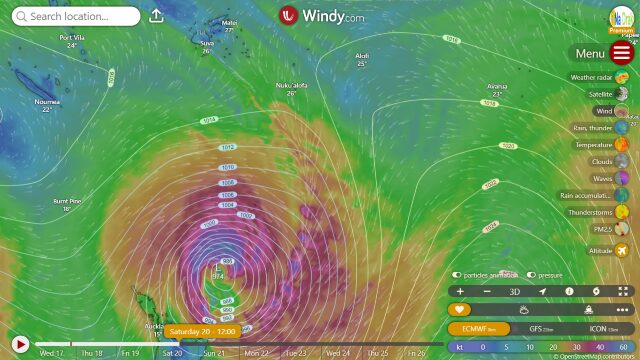
The rapid development of a weak low pressure system that is not even in existence at this time and first identified late tomorrow (Thursday) night is extremely significant, and this explosive deepening has only really happened over the past 2 model runs. I wanted to see how real this scenario is so I waited for two runs of the model to be sure the first one wasn’t a sprious “one off” depiction of the evolving weather pattern. It isn’t, and other models generally agree with this prediction. To give you an idea of what we are talking about, the subtropical waters northeast of Cape Reinga to the north of NZ are forecast to see pressure drop from 1016hPa Thursday night to 972 hPa by noon Saturday – a 44 hPa drop in 36 hours.
Winds near the centre are forecast to reach hurricane force – average speeds of 70 knots with peak gusts up to 100 knots, as the low passes to the north then east of Cape Reinga during the day on Saturday. Any yachts en route to or from the tropics in or out of Opua or Auckland (or any port on the north island of NZ in this region for that matter) over the next few days will find themselves in seriously catastrophic weather. This is likely to be very much like the weather experienced during the Auckland to Tonga Yacht Race in 1994.
Links:
………………………………
Noonsite has not independently verified this information.
………………………………
Find out all news, reports, links and comments posted on Noonsite, plus cruising information from around the world, by subscribing to our FREE monthly newsletter. Go to https://www.noonsite.com/newsletter/.
Related to following destinations: Auckland, Fiji, Kadavu, New Caledonia, New Zealand, North Island (New Zealand), Opua (Bay of Islands), Port Denarau, Viti Levu
Comments