

Pitcairn Island: Royal Navy finds Henderson Island in the “Wrong Place”
Uninhabited Henderson Island, one of four in the remote South Pacific Pitcairn Island chain, has been in the “wrong place” for 85 years, according to a recent visit by a Royal Navy warship.
Published 3 years ago
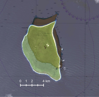
Sailors on a Royal Navy warship have proven a remote Pacific island has been in the “wrong place” for 85 years. It turns out that Henderson Island in the South Pacific is one mile (1.6kms) south of the position marked on nautical charts since 1937.
Henderson Island lies about 3,600 miles (5794kms) from Chile to the east and 3200 miles (5150kms) from New Zealand to the southwest.
- The Royal Navy has re-located Henderson Island part of the remote South Pacific Pitcairn Island chain.
Regularly-transited areas are well covered by up-to-date UK Hydrographic Office charts, but the Pitcairn chain is so remote that it has only had some satellite-based data collection in recent years. The satellite data suggested that the island’s position on historical charts was inaccurate, so HMS Spey offered to assist with data gathering.
Spey is not a dedicated survey vessel, but navigator Lieutenant Michael Royle used radar imagery and GPS data to conduct a simple check of the island’s position, overlaying the details on the existing charts of the Pitcairn chain.
The work by Spey is part of a wider British program to update maritime charts of waters around the UK’s Overseas Territories and improve navigation. The program uses sonar, airborne laser techniques and satellites to better understand, manage and protect the marine estates of these territories.
As well as some outdated charts, knowledge about the waters around the entire Pitcairn chain is limited, so at all four islands – Pitcairn, Henderson, Ducie and Oeno – HMS Spey launched her sea boat and crew filled tanks with water.
“Scientists in the UK have really scant data about the ocean in this region – its salinity, temperature, water pressure and the like,” Lt Royle added. “They are keen to understand climate change in the area.”
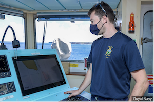
- HMS Spey has been mapping the seas around British Overseas Territories. (c) Royal Navy
Portsmouth-based Spey is on a five-year mission to the Indo-Pacific region with her sister HMS Tamar, a mission which has already seen her help the people of Tonga in the wake of the recent tsunami.
Henderson Island is perhaps known best for its least glamorous feature. Pacific currents carry large volumes of floating debris to the island. As many as 40 million items of plastic and rubbish litter Henderson’s beaches and it has been dubbed the “most polluted island in the world.”
………………………………………………………………………………………………………………………………………..
Related News:
Navy Finds Henderson Island Charted in Wrong Place (Royal Navy)
………………………………………………………………………………………………………………………………………..
Noonsite has not independently verified this information.
Related to following destinations: Pitcairn Island
Related to the following Cruising Resources: Circumnavigation, Pacific Ocean South, Routing
Comments