Pacific Ocean: Eastern and Western areas affected by Cyclonic Weather
Both sides of the Pacific Ocean have been alive with cyclonic weather activity this week with Super Typhoon Bolaven bringing heavy rain and strong winds to Guam and the Northern Mariana Islands in the western Pacific and Hurricane Lidia hitting the Pacific Coast of Mexico as a Category 4 storm.
Published 11 months ago
Western Pacific – Super Typhoon Bolaven
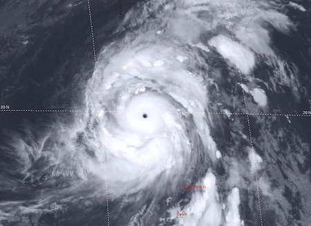
Super Typhoon Bolaven has now strengthened into powerful Category 5 storm and is currently roaming the Western Pacific. Packing sustained winds to 180 mph and gusts to 215 mph, it is the Earth’s second-strongest storm this year. The storm is centered more than 2,000 miles east-northeast of the Philippines and is heading northward over open water
Typhoon Bolaven was first categorised as tropical storm on Saturday October 7 when it was about several hundred miles to the southeast of Guam. By Wednesday night, this week Bolaven had rapidly intensified into a violent typhoon with sustained winds of over 130 mph (about 210 km/h).
A peak wind gust of 68 mph (109 km/h) was recorded on Saipan Island, part of the Northern Mariana Islands, as Bolaven passed over the region. Wind gusts of 46 mph (74 km/h) were observed at Guam International Airport on Tuesday October 10 as the center of Typhoon Bolaven passed roughly 50 miles (80 km) northeast of the island.
Bolaven is expected to remain over the North Pacific, avoiding land as it slowly weakens upon encountering cooler waters. However, the system will still influence the weather half a world away. Forecasters expect Bolaven will slam into the jet stream, bending it and infusing it with energy and ultimately affecting the weather over North America. For now, Bolaven is mainly a hazard mainly to mariners and aviation.
Eastern Pacific – Hurricane Lidia
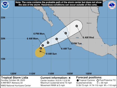
While Hurricane Lidia hit Mexico as a Category 4 storm, bringing wind speeds of up to 140mph (220km/h), it weakened as it moved inland, with the US National Hurricane Center (NHC) downgrading it to Category 2 status.
Lidia came ashore near the popular beach resort of Puerto Vallarta with maximum sustained winds of around 220 kilometers per hour, according to the U.S. National Hurricane Center. Local authorities listed damage on social media, reporting that homes and buildings were flooded, roads blocked and the Rio Pitillal overflowed as the storm passed through.
The NHC said Lidia was moving east-northeast at 17 mph (28 km/h) and should weaken quickly as it moved over elevated terrain in west-central Mexico.
“Life-threatening hurricane-force winds are expected along the path of the storm overnight,” the NHC added, warning of dangerous water levels, flash flooding and swells on the Pacific coast.
Parts of Mexico’s Pacific coastline have already seen significant flooding this week from Tropical Storm Max.
Hurricanes hit Mexico every year on both its Pacific and Atlantic coasts. The country’s official hurricane season runs from May to November, with most storms developing between July and October.
………………………………
Related News:
- Category 5 Typhoon in Pacific (Washington Post)
- Typhoon Bolaven Explodes into Violent Typhoon (Accuweather)
- ‘Extremely Dangerous’ Hurricane Lidia hits Mexico Coast (BBC News)
- Hurricane Lidia takes aim at Puerto Vallarta Resort (AP News)
………………………………
Related Links:
- Noonsite Cruising Resources: Weather
- NOAA National Hurricane Center
- NOAA Climate Prediction Center
- Saffir-Simpson Hurricane Wind Scale
- Atlantic Multidecadal Oscillation
- Yale Climate Connections
………………………………
Find out all news, reports, links and comments posted on Noonsite, plus cruising information from around the world, by subscribing to our FREE monthly newsletter. Go to https://www.noonsite.com/newsletter/.
Related to following destinations: Apra Harbour, Guam, Hagatna, Mexico, Northern Marianas, Puerto Vallarta, Rota (Northern Marianas), Tanapag Harbour (Saipan), Tinian, West Coast (Mexico)
Related to the following Cruising Resources: Circumnavigation, Hurricanes and Tropical Cyclones, Pacific Ocean East, Pacific Ocean West, Routing, Weather
Comments