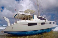
MAYDAY! On passage from Mo’orea to Huahine catamaran “Tanda Malaika” violently hits an unmarked reef
When they asked us what happened and we told them that our chart did not show a reef, they asked us if we had been using Navionic charts, and I said yes. He then shook his head and said that at least five boats end up on those reefs a year who were using Navionic charts.
Published 7 years ago, updated 6 years ago


Tanda Malaika has been their home for over 2 years and they all have become quite experienced and passionate sailors.
It was dark and they were almost to their destination. Their Navionics charts incorrectly indicated they were in deep water and the boat hit a huge reef. 8-10 ft waves pushed the boat further and further onto the coral. Their home immediately began taking on water. Other boats in the surrounding area attempted to assist the Govatos Family but it was soon obvious they had no choice but to get the coast guard involved. They were flown by helicopter to Huahine.
All the crew were safely evacuated and no one was hurt, Tanda Malaika however still remains on the reef and has taken on so much water and damage that she will have to be sunk. The family were between insurance providers when this event occurred. The salvage company will charge $5000 an hour as they work to tow the boat off the reef and into deeper water to sink. The family also have to pay another salvage company to remove the sails, generator and possibly the mast.
Belinda Govatos wrote a first-hand account of the disaster and also identifies some valuable lessons learned.
Read the full write up at https://adventuresofatribe.com/2017/07/23/mayday/


Just a clarification, sorry to reply to an old post but given the number of ppl who hit this reef because of Navionics (another one just did in 2021), I thought I’d explain.
People are likely using sonar mode, which doesn’t display the reef in a clear, clear, manner, like so: https://100r.co/media/blog/huahine/huahine12.jpg
The dotted line shows the reef, although it is very subtle. Although all those lines tight together, indicative of a ‘shelf’ ought to have rung some alarm bells. In any case, sailors shouldn’t use sonar mode when sailing. The outline of the reef is very clear in the regular mode.
But still, I agree they shouldn’t have been there at night… approaching any reef-strewn island in the blind is a bit careless. This could have been avoided had they looked at a map of the land beforehand… or satellite images. A sad, sad loss.
The headline is very misleading. The barrier reef around Huahine is clearly marked on Navionics chart, I use them myself ( plus paper charts I might ad) and I sailed past the wreck in early August, but I gave the reef a good offing as any prudent sailor would.
This wreck was clearly caused by poor seamanship and no other reason. What on earth was he doing passing so close to the reef in the dark, so near his destination, in his words and he was just about to sit down to dinner! Words almost fail me at the stupidity of this skipper.
If he was close to the reef how did he miss hearing the sound and sight of the breaking waves? Closing a reef or entrance to a reef I certainly wouldn’t be thinking of dinner. That could wait until you were safely in and at anchor. It was not the chart at fault it was the skipper. Chris skipper of Sea Bear
Written by John Freeland, circumnavigator. Writing from Avea Bay, Huahine.
In case you think this tragic shipwreck is about poor charting and not about lack of experience (or just plain human error). I can gladly send copies of the screenshots of the vessel’s initial location on the reef in relation the navionics chart.
This wreck has absolutely NOTHING to do with charts unless you consider a skipper not paying attention to them a charting problem. I have been anchored in view of the wrecked vessel for a week. As a circumnavigator who has been in Huahine several times, I am very put off by the ridiculous contention that this wreck is in any way related to chart accuracy.
I find it annoying when Navionics is blamed. Here is response from Navionics: Thank you for contacting Navionics. We were very sorry to learn of this unfortunate incident. The Navionics chart of Huahine, is derived from official French Hydrographic Office Charts as well as satellite imagery.
Despite our accuracy, charts have errors whether it is a result of survey errors or source errors. This applies to ALL charts, whether government or private, official or otherwise. The International Hydrographic Organization stated that less than 10% of the seas are charted as well as the Moon, and even that 10% contains errors.
This is why the common rules of navigation require that skippers, in addition to official charts, use multiple sources of information, including sailing directions, cruising guides, radar, sonar, local diligence, and good eyesight. With the best chart in the world, one should never get close to coral reefs at full speed and at night, but rather when the sun is highest, at very slow speed, and with a person on watch on the bow. This is the only way to ensure that breaking waves be spotted from a distance, and that possible uncharted coral heads be avoided.
The warnings that go with all charts are not there to protect the chart makers, but rather to protect the chart users from making mistakes in over-reliance on any one tool of navigation. A review of this topic can be found here https://www.navionics.com/fra/blog/post/proper-use-of-electronic-charts/
Best regards,
Mary-Ellen Smith
Navionics Global Customer Service Manager