Japan: Typhoon Shanshan Lashes Southwestern Region
Southwestern Japan braced for what officials said could have been one of the strongest storms to ever hit the SW region of Japan, as some residents in the path of Typhoon Shanshan were ordered to evacuate and major firms such as Toyota closed their factories. However, fortunately, the majority of places managed to dodge any major impact from the hurricane, as Kirk Patterson of Konpira Consulting reports.
Published 3 weeks ago
Update 30 August:
From Kirk Patterson – Konpira Consulting, based in Kyushu:
“As it turns out, Shanshan seems not to have had any significant impact on marinas and their boats. At one point, it was forecast to make a direct hit on the Nagasaki area (with four marinas), but it made it a sharp turn to the east before getting that far. And then it was forecast to hit a marina on the east coast of Kyushu, but it weakened and avoided that too.
And then, instead of barreling west-to-east through the Seto Inland Sea (where many marinas are located), as was forecast at one point, the typhoon weakened and stayed over land for the most part. So I haven’t heard of any damage in that area.
Certainly, many of the fishing ports on the SW coast of Kyushu and nearby small islands were really hammered, so it would be surprising if there were not a few badly damaged fishing boats. And there is a “mini-marina” in that area that may have had damage, but it is in a very well-protected spot so it might also have been spared (I was on my boat there once when a 70-knot typhoon passed within 20NMs but winds at my boat never exceeded 20 knots).
So, all in all, it looks like we dodged a bullet…again! Fortunately, all my client boats dotted throughout the typhoon area are fine.
This typhoon was very unusual in two respects.
1. The forecasted track changed dramatically, every day — initially, it was forecast to approach the Osaka area and then curve toward Tokyo…and then to hit Osaka directly…and then to go central Shikoku….etc…every forecast moved the track about 20-30NMs to the west….so the actual track was about 700NMs to the west of the first forecasted track! That would have made it very difficult for boaters to know if they should move their boats to a safer location or how to prepare their boats. For example, as the typhoon was crossing Kyushu it made a sudden, sharp to the north….so a marina on the east coast that had prepared for winds coming from the north (as had been forecast for a week) suddenly had to deal with winds coming from the south.
2. The typhoon moved extremely slowly, so dumping a lot of rain over a longer period than normal….typically, when a typhoon reaches land, it weakens and therefore speeds up, so the rain only lasts for 12-24 hours….but this time the rain continued for 48+ hours. So this was much more of a rain event than a wind event…thereby triggering a lot of landslides and flooding (the last report I read mentioned 7 deaths, 6 from landslides and 1 when a man fell off his small boat [why he was on a small boat during a typhoon is under investigation!]).
This article in the Japan Times, discussing – in very specific, technical terms – how climate change contributed to the challenge of accurately forecasting this typhoon’s track and to the typhoon’s unusually slow movement, is very interesting.”
Original News Report: Emergency Warning Issued
Japan’s Meteorological Agency issued an emergency warning saying Typhoon Shanshan could bring flooding, landslides and wind strong enough to knock down some houses.
The Agency says Typhoon Shanshan is set to reach southern Kyushu and possibly make landfall Thursday August 29 where it forecasts up to 60 centimeters (23.6 inches) of rainfall in 24 hours. It also said the typhoon will bring strong winds, high waves and significant rainfall to most of the country, particularly the Kagoshima prefecture.
Particularly Nasty Typhoon
Kirk Patterson, the Chief Sailing Officer of Konpira Consulting is based in Fukuoka, at the north end of Kyushu and told Noonsite that Typhoon Shanshan looked like it was going to be particularly nasty for some areas of Japan.
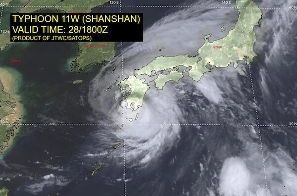
“I am hoping Shanshan won’t have major impact here,” he said. “Currently just south of Kyushu, with winds of 100 knots and gusts to 125, with waves of 10+ meters, the typhoon is forecast to go up the west coast of Kyushu and then make a really sharp E/SSE turn at around Nagasaki. It will lose power as it crosses the Kyushu mountains, so the winds will drop to about 50/70 knots as it passes along the south coast of Shikoku before curving toward Osaka Bay.
“There are several marinas on the west-central coast of Kyushu (Nagasaki area) that will experience extreme conditions, so it wouldn’t be surprising if the marinas and some of the boats suffer some damage. Of greater concern is the thousands of small fishing boats moored in fishing ports throughout Kyushu and Shikoku that are typically moored bow-in along concrete walls. They are more at risk of being damaged.
“In general, though, Japan has centuries of experience in dealing with typhoons, so the ports are as well protected as they can possibly be, often with double or triple breakwaters, so the typhoon will cause much less damage here than a similar-sized typhoon would cause in most other countries.”
Harsh Weather Systems
Japanese weather and government officials are concerned about extensive damage as the typhoon slowly sweeps up the Japanese archipelago over the next few days, threatening floods and landslides and paralyzing transportation, businesses and daily activity.
Disaster Management Minister Yoshifumi Matsumura, at a task force meeting Wednesday, said the typhoon could cause “unprecedented” levels of violent winds, high waves, storm surges and heavy rain.
Shanshan is the latest harsh weather system to hit Japan following Typhoon Ampil, which also led to blackouts and evacuations in mid August.
…………………………………
Related News:
- Japan Issues Emergency Warning as Powerful Typhoon Nears (Reuters)
- Typhoon Shanshan Dumping Rain on Parts of Japan (AP News)
- Heavy Rain from Typhoon Shanshan Causes Landslides (The Independent UK)
…………………………………
Related Links
…………………………………
Find out all news, reports, links and comments posted on Noonsite, plus cruising information from around the world, by subscribing to our FREE monthly newsletter. Go to https://www.noonsite.com/newsletter/.
Related to following destinations: Aioi, Akune, Amakusa, Fukuoka (Hakata), Hirado, Inland Sea (Seto Naikai), Japan, Kagoshima, Kasasa, Kyushu, Makurazaki, Miyazaki, Nagasaki, Nishinomiya, Nomo Ko, Oita, Shimonoseki, Sumoto (Awaji Island)
Related to the following Cruising Resources: Hurricanes and Tropical Cyclones, Weather
Comments