
Environment: Tobago Oil Spill Detected Heading Towards Grenada Again
Four months after oil first washed up on Tobago’s coastlines, hydrocarbons from the capsized Gulfstream barge off the Cove Eco-Industrial Park, Tobago, spilled into the ocean once more according to a report from the Trinidad and Tobago Weather Center.
Published 3 months ago
The Catastrophe Continues
Source: Trinidad & Tobago Weather Center
The oil-like substance first spilled into the ocean in early February 2024, initially covering the windward coastlines of Tobago. Trinidad & Tobago Authorities said the oil spill was from a vessel – later identified at the Gulfstream – which washed up on Cove Reef, Tobago. Read the news story here. The oil-like substance spread approx. 88 kilometers west and northwest of Tobago and was later identified as bunker fuel. It affected some 15 km of Tobago’s southwestern coast, including Kilgwyn Bay, Canoe Bay, Petit Trou Lagoon, Rockly Bay, and Topaz Beach.
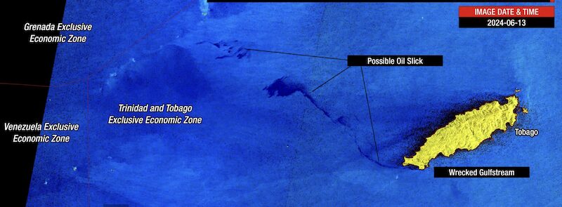
Satellite Images Detect Oil Slicks Moving
Images from the Copernicus Sentinel-1A satellite taken in early June 2024, have detected possible oil slicks moving out of Trinidad and Tobago’s marine area towards Grenada’s southernmost marine area of responsibility.
The Office of the Chief Secretary (OCS) of the Tobago House of Assembly (THA) said in a statement that a large amount of fuel had been discovered drifting away from the Gulfstream. Based on data analyzed by TTWC and sent to the Tobago Emergency Management Agency (TEMA), an anomaly similar to what was seen in February this year was seen on satellite data. The anomaly measured 39.5 nautical miles, approximately 74 kilometers away from western Tobago and extended from the west to northwest of Tobago into the Caribbean Sea.
Two Main Areas
There are two main areas of the possible oil slick. The area closest to Grenada’s marine waters, approximately 65.6 kilometers to the island’s southeast, measures approximately 17 kilometers in length, while the larger area extending from Tobago measures 54 kilometers in length. Both areas are moving generally west.
It is important to note that the thickness of the slick is not known, and this anomaly could also be sheen. Hydrocarbons, particularly when it is a thin slick or just sheen, are naturally dispersed into the ocean through wind and wave action.
According to the THA, the existing weather and sea conditions, including high tides and high wave swells, have disturbed the vessel, resulting in hydrocarbon deposits.
The Ministry of Energy and Energy Industries (MEEl) continues to manage the operations for the de-inventory of hydrocarbons from the capsized vessel off the coast of Cove, Tobago. The de-inventory process involves pumping hydrocarbons from the cargo tanks on the vessel to a temporary storage location at Cove, Tobago. Tanker trucks then transport the hydrocarbons from the temporary storage location to the Port of Scarborough, where it is transferred to a bunkering vessel. This vessel then journeys to Pointe-a-Pierre, Trinidad, where the hydrocarbons will be offloaded and stored in a storage tank.
This is the second time oil from the Gulfstream has approached Grenada’s southernmost territorial waters.
………………………………
Related News:
- Oil Spill Nearing Grenada Waters Again (June 2024)
- Capsized Barge off Tobago Stops Spilling Oil (March 2024)
- Oil Spill Clean Up Continues in Tobago (February 2024)
- Tobago Catastrophic Oil Spill (February 2024 Noonsite)
………………………………
Noonsite has not independently verified this information.
………………………………
Find out all news, reports, links and comments posted on Noonsite, plus cruising information from around the world, by subscribing to our FREE monthly newsletter. Go to https://www.noonsite.com/newsletter/.
Related to following destinations: Charlotteville, Clarkes Court Bay, Grenada, Grenville, Hog Island, Mt Hartman Bay, Petit Martinique, Port Egmont (Le Phare Bleu Bay), Prickly Bay, Sauteurs, Scarborough (Tobago), St. Davids, St. George's, Store Bay, Tobago, Trinidad & Tobago, True Blue Bay, Tyrell Bay & Hillsborough (Carriacou)
Related to the following Cruising Resources: Caribbean Sea, Environment, General, Routing
Comments