Cook Islands, Aitutaki: Channel Dredging Part of New Port Project
Dredging works are currently underway at Arutanga Harbour, Aitutaki in the Cook Islands in Stage One of a new project that will eventually see more space and moorings for yachts travelling through the Cook Islands. Aitutaki is one of the two ports of entry into the Cooks.
Published 1 year ago
Aitutaki lies 220 km north of Rarotonga. Arutanga, the main village located on the west side, has the only harbour on the island and is a port of entry. Currently it is one of only two ports of entry for the Cook Islands (the other being Avatiu Port (Rarotonga).
Arutanga Harbour is undergoing some major changes, according to Andrew Bereson who visited there recently and which have been confirmed by John Jessie, Aitutkai’s Harbour Master.
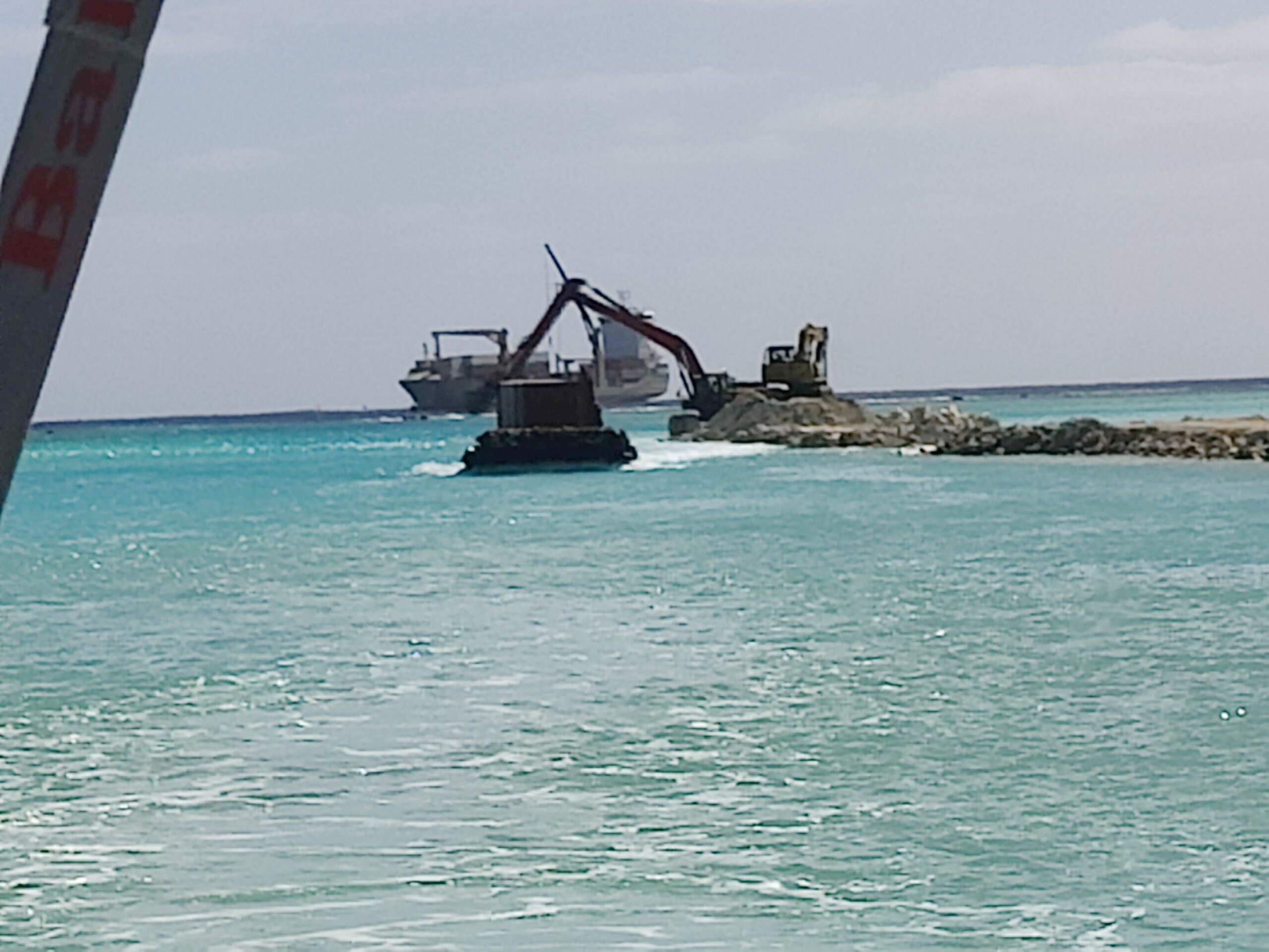
“Currently stage one of the work being carried out is the dredging of the passage to 6m depth and widening it to 15m, as well as the installation of light poles,” said John Jessie. “This should be completed by the end of August 2023.
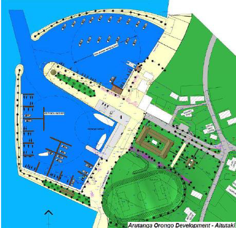
“The next stage involves extending the port, creating more space for operations and storage and also developing the marina for local fishermen, charter operations and providing more space/moorings for yachts traveling through Aitutaki.”


The entrance channel to the Arutanga Port was naturally formed by a fresh water stream and later modified by the US Military during World War II. Some improvements were reportedly carried out over subsequent years, although minor.
The current dredging operation is part of the much larger Orongo Development Master Plan and is being managed by the Cook Islands Investment Corporation.
The Orongo Development Master Plan was commissioned in 2011 by the Cook Islands Port Authority and Aitutaki Island Council and comprises the following components:
- Dredging works to safely allow yachts, cruise ship tenders and small ships into the harbour;
- Renewal of the wharf infrastructure where condition is poor, including infilling a silted-up part of the basin to create more cargo handling space;
- Structural works at the port to improve resistance against the effects of sea level rise caused by climate change; and
- Tourism-focused development of the port and marina.
Channel Depth
Andrew Bereson from SV Second Sun (Young Sun 43′ with 6.5′ draft) arrived at Aitutaki on July 11, 2023, and was able to give Noonsite an update on the dredging, harbour development and anchoring situation.
“We spoke to the dredger operator over the radio, inquiring about the channel depth and he assured us the depth was 4-5 meters all the way into the harbor. Although we had no difficulty carrying our 6.5′ (2m) draft through the channel into town, our sonar gave a least depth of 5.9′ or 1.8 meters.
“The boat did not act as if it had touched the bottom so we suspect the bottom is very soft and that we pushed through a shallow spot that had silted up. It is unclear how deep the channel really is, but we had no difficulty. We should note we had approximately 1 foot of tide in our favor at the time.”


Channel Markers
Andrew also noted there was a green flashing light at the entrance to the channel that is not shown on charts.
“While reports indicate the channel is marked with stakes on one side, that no longer seems to be the case,” he said. “We encountered stakes in gated pairs showing both sides of the channel all the way into the harbour, which was great!.”
The Harbor
“The two new jetties or wharves are not shown on any charts. One extends out from the inner harbor along the north (port hand when entering) side of the channel. The dredger was working on both deepening the channel and building this jetty. There is also a new wharf that wraps around the southern part of the harbor. This wharf cuts through or abuts the anchorage shown on the chart.”
Anchoring
Andrew said they anchored inside the harbor where the new wharf is under construction.
“This new wharf almost completely encloses the harbour and with us and two other boats here, all swinging on one anchor, it is very tight,” he said.
“We anchored, along with another boat, inside the harbour in 10′-12′ of water with our sterns close to the new southern wharf. There is no place to secure sterns to the wharf, but if there were a few more boats we might all need to set anchors or stakes on the wharf to keep sterns from swinging.
“When the tide is low and the wind is light we occasionally catch on the bottom and don’t swing. The same is happening to the other monohull in the harbor. We haven’t felt as if we have hit bottom but we clearly touch from time to time. It has not been a problem and the holding in this harbour is excellent!”
“It looks like the crew is setting up mooring spots for local boats along the new wharf. They have set a few anchors with floats just off the wharf and set a few anchors into the edge of the wharf itself. If there were boats secured to these floats there would not be room for more than one or two cruising boats in the harbor. When the wind blows one way, we are only 10 feet or so from the wharf. When the wind blows the opposite way we are just clear of the channel.”
Future Plans
“We are told the plan is for a new yacht basin north of the north jetty, which is under construction. When that basin is complete yachts will be expected to use that basin and will no longer be allowed into the basin where we are currently anchored. It seems it will be a while before the planned yacht basin is completed, though.”
………………………………
Related Links:
………………………………
Find out all news, reports, links and comments posted on Noonsite, plus cruising information from around the world, by subscribing to our FREE monthly newsletter. Go to https://www.noonsite.com/newsletter/.
Related to following destinations: Aitutaki, Cook Islands, Southern Cook Islands
Related to the following Cruising Resources: Circumnavigation, Circumnavigation, Pacific Crossing, Pacific Ocean South, Routing


