Noonsite has not independently verified this information.
Azores Mid-Atlantic: Lonely Lorenzo to bring Hurricane Force Winds Tomorrow
Lorenzo is an oddity, but a strong one at that, forming uncharacteristically too far east in the Atlantic and maintaining strength as it barrels toward the Azores.
Published 5 years ago


- https://www.nhc.noaa.gov
Tropical Storm Lorenzo formed a week ago mid-Atlantic and in just five days developed into a category 5 hurricane with winds reaching 160 mph (260 km/h). To put this in perspective, Live Science reports that since the 1920s, only 35 Category 5 storms — hurricanes with winds of 157 mph (252 km/h) or higher — have formed in the Atlantic.
Oddly, however, Lorenzo is the first hurricane of this strength to form so far east in the Atlantic.
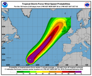
Currently heading in a NE direction, Lorenzo is expected to bring hurricane and tropical-storm-force winds to the Azores tomorrow night into Wednesday morning, according to the National Hurricane Center (NHC).
Lorenzo’s strong winds are generating powerful swells through the North Atlantic basin and waves building towards the Azores and northern Europe will be substantial. The NHC estimate wave heights nearing 100 feet (31 meters) and rip currents and surf conditions that could be life-threatening.
………………………….
As Reported By:
https://www.livescience.com/hurricane-lorenzo-farthest-east.html
NHC – Key Messages for Hurricane Lorenzo
Related to following destinations: Azores
Related to the following Cruising Resources: Hurricanes and Tropical Cyclones, Weather


