Honduras Islands: Cruising to the Swan and Guanaja Islands
(February 8, 2019) – Approach, anchoring and clearance information from regular Noonsite contributor Brian Simm.
Published 6 years ago


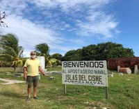
The Swan Islands, or Islas Santanilla
Approach:
Taking the easy downwind route from Grand Cayman to the Honduran Bay Islands we stopped at the Swan islands for two nights. We were pushed for the last 100 miles by a 1.5 to 2 knot west setting current, reaching 7-8 knot in 10kn – 12kn winds.
Anchorage:
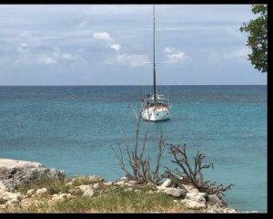
The trade wind anchorage is at the SW corner of Great Swan. There are two bays, we first stopped in the larger northern bay, anchoring under sail. Then when we got the engine started we moved to the southern bay approaching outside in 8-10m depth then due east to drop at N17.24.16 W83.56.60.


Choose a sand patch, 3-5m, deep in bay and as close as you can to steeply shelving beach, leaving swinging room to old concrete/rock jetty. On both Cmap and Navionics (much the more detailed) this was shown to be just on land…. but not so. The anchorage was surprisingly calm and well protected from NNW to S with only slight roll in the light Easterly breeze. We did not investigate the reef anchorage reported on Navionics round the NW point. Older cruising notes (Stone and Hays, 1970s ) indicate shelter possible at several points round islands according to wind direction.
Formalities:
The Iguanas on watch clearly reported us, and soon the dock had a group of young men and we were waved to come in by uniformed and armed marines. The reception was friendly and with help from one partial English speaker formalities consisted of a welcoming handshake and smartphone photos of our passports. We also handed over photocopies of passports and yacht registration which were taken.
The navy detachment of some 30 men appears to laze around, keep sheep and grow bananas. Indicating our destination as the Bay Islands, all was fine. No departure formalities were made.


Guanaja, Bay Islands of Honduras
Approach:
Arriving from Swan islands at dawn we found both Cmap and Navionics to be confusing, inaccurate and actually misleading as to depths (the main hazards are shown adequately). We have a scanner and throughout the inner area of the sound/lagoon the bottom is very erratic with depths jumping up and down from 3m to 20m+ and back again over short distances.
In fact once through the wide inner reef pass at N16.26.37 W82.52.50 the lagoon is sensibly navigable at 3m depth or more. All obstacles shallower than this are either built on or clearly marked and visible in the daytime. The island town itself has over the years been built out on piles to the 8m line all round.
Anchorage:
The town island is best taken anti-clockwise round north end (reef off SW corner) to the sheltered trade wind anchorage off a fish dock at N16.26.50 W85.53.44. The Port Captain may request a sail past of his dock to take a photo of your boat, you can go alongside but concrete jetty is rather high, although has many tire fenders. There is a dinghy dock to port of jetty.
The most sheltered anchorage at El bight may be entered either from town along about 200m offshore of the main island with visual lookout for obstacles or from inside the reefs through a channel between Dunbar island to port ( a 5 story hotel built on a single rock ) and visibly marked reefs extending from headland to starboard. Entry around N16.27.08 W85.52.24 crossing 3-4m area before turning to starboard and closing beach for anchorage in 5m or so at N16.27.26 W85.52.07. Note again depths very variable over short distances.
Formalities:
You will probably be picked up by an English speaking ‘guide’ who will take you to immigration, bank with ATM, trigo for internet SIM and data, shopping and back to Port Captain. Port captain rather slow.. we were initially anchored at El Bight in windy conditions and dinghied in. Told to return with boat next AM as he likes to photograph you from shore (no mention of fine as above ) then to come back later as he processed our details through Headquarters office. We returned to boat for coffee and lunch….. before returning at set time. Port Captain fee for entry and Cruising Permit: $20; Immigration $5 PP. So total entry for boat +2 people is $30. Guide will want 10 dollar tip, but we did not mind this.
All friendly and English and Spanish are spoken. Once checked in you are clear to all Honduran islands until final check out.
Brian Simm
SV Scraatch
The opinions expressed in this article are the author’s own and do not reflect the view of noonsite.com or the World Cruising Club.
Related to following destinations: Atlantic (Honduras), Bay Islands, Guanaja, Honduras, Swan Island


