
South Pacific: Australia and Fiji on Cyclone Watch
The South Pacific Island nation of Fiji and the Queensland and Western Australian states of Australia are under tropical cyclone watch as meteorological services in both countries keep track of several tropical low pressure systems that may develop into tropical cyclones over the weekend and into early next week
Published 1 month ago

Warnings for Fiji as Tropical Cyclone Rae Intensifies to Category 2
Updated: February 24, 2025
Tropical Cyclone Rae has strengthened to a Category 2 storm and multiple warnings are in place in Fiji. Rae was just east of Cikobia and tracking south-southwest towards the Lau Group, the Fiji Meteorological Service reported just before 4.30am Monday Fiji time.
The forecaster said Rae was expected to become a severe tropical cyclone later on Monday.
Currently the Fiji Met Service has issued a hurricane warning for the Moala Group, a gale warning for the eastern parts of Vanua Levu, and a heavy rain warning for the whole Fiji group. Maritime warnings are also in place.
Tonga Also on Alert
The Tonga Meteorological Service has also issued a number of alerts due to Tropical Cyclone Rae. A tropical cyclone warning is in place for Niuafo’ou and Niuatoputapu, with a cyclone alert for Vava’u and Ha’apai. A heavy rain warning and flash flood advisory are in place for all land areas in Tonga.
Australia – Queensland and Western Australia
Updated: February 24, 2025:
TC Alfred
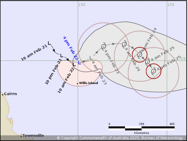
Tropical Cyclone Alfred (Tropical Low 22U) is strengthening as it moves slowly eastwards in the Coral Sea, well offshore of the north Queensland coast according to an updated advisory from the Australian Bureau of Meteorology.
On Tuesday February 25, Alfred is forecast to turn southeast and then south while continuing to intensify through to the middle of the week. There is high confidence that Alfred will remain well off the Queensland coast until at least late in the week. Beyond that, the track becomes highly uncertain and there is a risk it will move closer to the central Queensland coast over the weekend.
TC Bianca
Tropical Cyclone Bianca (Tropical Low 21U) is located in the Indian Ocean well to the west-northwest of the WA town of Exmouth and is moving towards the southwest. It has reached Category 2 intensity and is expected to strengthen further today and Tuesday as it tracks south-southwest, remaining well offshore from the Western Australian coast. By Wednesday, it is forecast to start weakening.
Earlier Reports
Australia’s Bureau of Metereology (BOM) says there is a tropical low (21U) slowly developing to the north of the Western Australia (WA)’s Pilbara but it is expected to remain well off the WA coast. The risk of 21U developing into a tropical cyclone increases to High from Monday but the BOM says it does not pose a direct threat to Western Australian mainland or island communities. During next week, 21U is expected to curve towards the south and the southeast, while remaining well off the Western Australian coast before weakening from mid week.
High Chance of Tropical Cyclone in Coral Sea
The BOM says there is a high chance that a tropical low (22U) currently in the northern Coral Sea off the coast of Queensland, could reach tropical cyclone intensity late weekend. Tropical low 22U, is forming off the north Queensland coast and moving towards the southeast. Over the weekend and early next week, 22U is expected to move through the northern Coral Sea and develop, with ratings increasing to High from Sunday.
Tropical Low 22U is expected to continue to develop over the weekend while moving slowly east. It is forecast to develop into a tropical cyclone on Sunday.
During next week, the system is expected to turn southeast and then south while continuing to strengthen. Considerable uncertainty exists in the track the system will take beyond that, but there is a risk it will move closer to the central Queensland coast late next week.
Fiji on Alert
The Fiji Meteorological Service is also monitoring two tropical depressions which they say may affect Fiji in the next few days.
A tropical depression (TD08F) was located northeast of Niue, in a mostly favourable environment with some early signs of organisation, hence there is a MODERATE risk for it to develop into a tropical cyclone over the weekend whilst tracking southeast along the South Pacific Convergence Zone (SPCZ).
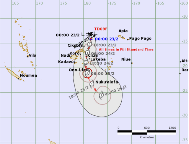
Another tropical low pressure was analysed north of Fiji along the SPCZ and was expected to gradually intensify and may develop into a tropical disturbance in the next 48 hours.
According to a Tropical Cyclone Bulletin from New Zealand’s Metservice, this tropical depression – TD09F – is expected to move slowly south over eastern parts of Fiji early next week while in a mostly favourable environment. However, model outlooks vary with the amount of development to be expected, hence there is a MODERATE risk that it will be a tropical cyclone from Monday through to Wednesday.
Cynthia Rasch from Port Denarau Marina said they have begun to implement cyclone preparedness plans and have advised vessel owners and marina tenants to implement their own safety plans.
.………………………………
Related News:
.………………………………
Related Links:
.………………………………
Find out all news, reports, links and comments posted on Noonsite, plus cruising information from around the world, by subscribing to our FREE monthly newsletter. Go to https://www.noonsite.com/newsletter/.
Related to following destinations: Abbot Point, Bowen, Brisbane, Broome, Bundaberg, Cairns, Daku Bay, Dampier, Fiji, Fulaga (Vulaga), Gladstone, Gold Coast, Kadavu, Kavala Bay, Lakeba, Lau Group, Lautoka (Vuda Point Marina), Levuka, Lucinda, Mackay, Mamanucas and Yasawas, Manly, Matuku, Mooloolaba, Mourilyan Harbour, Musket Cove, Oinafa, Ovalau, Pacific Harbour, Port Denarau, Port Douglas, Port Hedland, Port Hinchinbrook, Queensland, Rotuma, Savusavu, Scarborough (Australia), Somosomo, Suva, Taveuni, The Whitsunday Islands, Thursday Island, Tin Can Bay and Hervey Bay, Townsville, Vanua Balavu, Vanua Levu, Viani Bay, Viti Levu, Vunisea, Weipa, Western Australia, Yeppoon
Related to the following Cruising Resources: Hurricanes and Tropical Cyclones, Weather
Comments