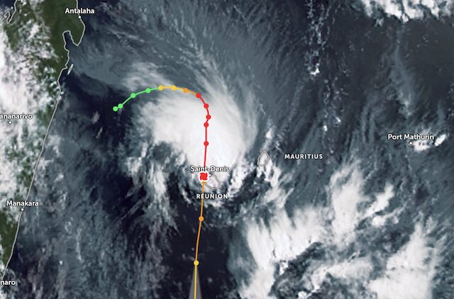
Indian Ocean: Cyclone Garance Slams into Reunion Island

Cyclone Garance has caused widespread damaged to the Indian Ocean island of La Reunion after it slammed into the French overseas territory on the morning of Friday February 28.
Published 10 months ago
Reunion Island is an overseas department and region of France, located east of Africa, 800 kilometres east of Madagascar in the Indian Ocean.
The Meteo France weather agency said the cyclone made landfall in the north of the island with wind speeds of up to 155 kph (96 mph), blowing away roofs and cutting power and access to drinking water for many residents. It exited the southwest of the island several hours later.
Prime Minister Francois Bayrou said at least three people had died, about 180,000 households had lost power and nearly 10% had no access to drinking water.
Wind speeds had dropped, Meteo France said, but 80-100 kph gusts were still possible, with heavy rains seen as a bigger risk. Weather conditions were expected to improve over the weekend.
“Brutal and Violent” Conditions
The “brutal and violent” conditions were worse than Cyclone Belal, which killed four people on the island in January 2024, Prefect Patrice Latron said.
Local authorities reduced the alert level by midday Friday to allow emergency services and police to leave their shelters. The top wind speed of 234km/h had not been recorded on the island since Cyclone Hollanda in February 1994.
In nearby Mauritius, authorities reopened the airport after the threat from the storm eased.
Tropical Storm Honde Skirts southern Madagascar
Meanwhile, a category 1-equivalent Severe Tropical Storm Honde has formed in the Mozambique channel and travelled south-east, where it is skirting the southern tip of Madagascar.
Uncommon Meteorological Event in Southern Hemisphere
An uncommon meteorological event unfolded last week when six named tropical cyclones were active simultaneously in the southern hemisphere, several in close proximity to one another, according to an online report from The Guardian.
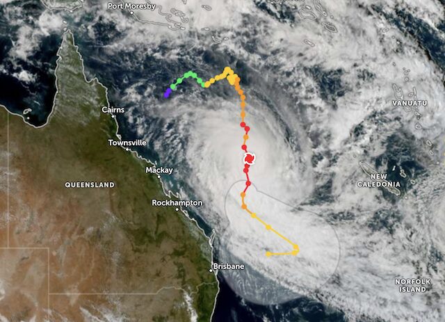
Three developed in the south-west Pacific. Severe Tropical Cyclone Alfred formed on 20 February in the Coral Sea to the north-east of Australia, reaching an intensity equivalent to a category 4 hurricane on Thursday February 27 with sustained winds of 105mph (170km/h) and gusts at about 140mph.
Alfred is still tracking south, moving roughly parallel to the Queensland coast, and warnings have been issued for strong winds and rough seas. Though Alfred is not expected to make landfall, the Australian Bureau of Meteorology is monitoring the cyclone as it remains uncertain how close it will pass by the coast.
………………………………
Related News:
- Three dead as Cyclone Garance hits Reunion Island in the Indian Ocean (Reuters)
- ‘Brutal’ Cyclone Sweeps Through Reunion Island (BBC)
- Cyclone Garance Smashes into Indian Ocean Island (CNN)
- Six Cyclones Swirl in the Southern Hemisphere (The Guardian)
………………………………
Related Links:
………………………………
Find out all news, reports, links and comments posted on Noonsite, plus cruising information from around the world, by subscribing to our FREE monthly newsletter. Go to https://www.noonsite.com/newsletter/.

Related to following destinations: Abbot Point, Australia, Bowen, Brisbane, Bundaberg, Cairns, Gladstone, Gold Coast, îles Eparses (Scattered Islands), Lucinda, Mackay, Manly, Mooloolaba, Mourilyan Harbour, Pointe des Galets (Le Port), Port Douglas, Port Hinchinbrook, Queensland, Reunion Island, Saint Gilles les Bains, Saint-Pierre, Scarborough (Australia), The Whitsunday Islands, Thursday Island, Tin Can Bay and Hervey Bay, Townsville, Yeppoon
Related to the following Cruising Resources: Hurricanes and Tropical Cyclones, Weather
Comments