Australia: Tropical Cyclone Alfred Slows Down off Queensland Coast
For the first time in more than 50 years a Tropical Cyclone is forecast to cross a densely populated part of Australia’s east coast. TC Alfred is already bringing damaging winds and huge swells to coastal areas of south-east Queensland and northern New South Wales and millions of people are bracing for the storm to make landfall.
Published 2 months ago

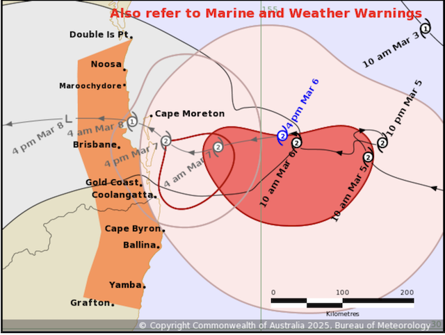
Updated: March 6 – Alfred Has Slowed Down
Tropical Cyclone Alfred continues to batter areas of south-east Queensland and northern New South Wales with damaging winds and powerful ocean swells, but the system has slowed down, with forecasters now saying that it might not make landfall until early Saturday morning March 8.
Australian Bureau of Meteorology cyclone team analyses was suggesting that Alfred would probably make landfall early on Friday morning. However, by Wednesday evening (March 5) the eye of the storm was slightly further away from the Queensland coast, after performing a full loop during the day instead of continuing to move towards the coast.
Cyclone experts are expecting Alfred to continue to move slowly and there was a suggestion it could stall as it approached the coast. Federal and State Government officials have described the slow passage of the storm as the “worst case scenario”, meaning a longer period of very heavy rainfall as the cyclone straddles the coast.
………………………………
A Turn for the Worse
Tropical Cyclone Alfred has intensified into a Category 2 system and is forecast to turn towards south-east Queensland later on Monday March 4 according to Australia’s Bureau of Meteorology (BOM).
BOM modelling shows the system, which is about 560 kilometres east of Brisbane, will start heading towards the coast before making landfall between Brisbane and the Sunshine Coast later this week.
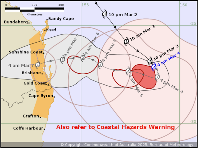
Australia Bureau of Meteorology (BOM) senior forecaster Jonathan How said the latest modelling suggests the cyclone is “probably more likely” to cross around the northern suburbs of Brisbane.
Alfred’s intensity may fluctuate in the coming days, but it is expected to make landfall at category 2 strength late Thursday or early Friday morning.
It will be the first time the south-east has been in the direct firing line of a tropical cyclone in several decades.
Mr How said the location of landfall “will be very critical” because the worst impacts will be felt on the southern side of the system.
“We are expecting to see pretty broadly 200 to 400 millimetres [of rain] … but we could even see isolated falls of 500 to 700mm, particularly in areas from the Gold Coast down towards the Northern Rivers,” he said.
Ambling Around
For almost two weeks, Tropical Cyclone Alfred ambled about the Coral Sea. Early on Sunday morning March 2, the cyclone passed below the Tropic of Capricorn, way off-track for the typical path a cyclone might take to the north Queensland coast.
Coastal communities across the south-east of Queensland and down into north-eastern New South Wales were preparing for gale-force winds of up to 120km/h. Authorities also warned of intense rainfall that could lead to dangerous and life-threatening flash flooding and abnormally high tides.
………………………………
Related News:
- BOM Watching System’s “Erratic Movement” (Australian Broadcasting Corporation)
- Tropical Cyclone Alfred Intensifies to Category 2 System (Radio New Zealand)
- Tropical Cyclone Alfred Could Make Landfall Near Brisbane (The Guardian)
- Cyclone Garance Slams into Reunion Island (Noonsite)
………………………………
Related Links:
………………………………
Find out all news, reports, links and comments posted on Noonsite, plus cruising information from around the world, by subscribing to our FREE monthly newsletter. Go to https://www.noonsite.com/newsletter/.
Related to following destinations: Abbot Point, Australia, Bowen, Brisbane, Bundaberg, Cairns, Coffs Harbour, Gladstone, Gold Coast, Lord Howe Island, Lucinda, Mackay, Manly, Mooloolaba, Mourilyan Harbour, New South Wales, Newcastle and Port Stephen, Port Douglas, Port Hinchinbrook, Queensland, Scarborough (Australia), The Whitsunday Islands, Thursday Island, Tin Can Bay and Hervey Bay, Townsville, Yeppoon
Related to the following Cruising Resources: Hurricanes and Tropical Cyclones, Weather
Comments