
Atlantic Hurricane Season: Nigel Breaks Named Storms Record
Hurricane Nigel, which has formed in the middle of the Atlantic Ocean, has broken the record for the most named storms during a set timeframe within an Atlantic Hurricane Season.
Published 1 year ago
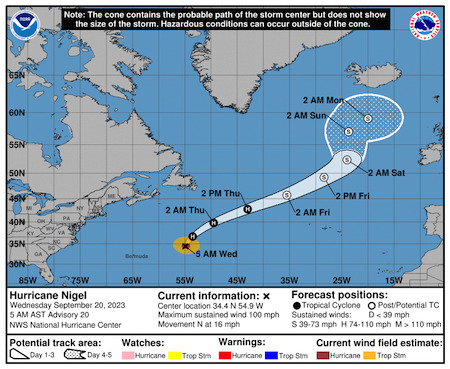
Nigel was the 14th named storm to form in the Atlantic in 2023 and 10th named storm to form since August 20. That’s the most named storms on record to form in the Atlantic between August 20 – September 16, breaking the old record of nine named storms set in 2020 according to NOAA’s National Hurricane Center.
Nigel was about 765 miles east-southeast of Bermuda on Monday night, and moving northwest at 12 m.p.h. It was expected to turn north late Tuesday, the Hurricane Center said. There were no warnings or watches for land in effect, but the Hurricane Center said that the storm was expected to generate substantial swells that could cause dangerous surf conditions near Bermuda by the middle of the week.
In the UK, forecasters said that while Nigel was expected to weaken in the coming days, the storm would make its presence felt there and create unsettled conditions, just days after the tail end of Hurricane Lee brought heavy rain and winds to parts of Wales, north west England and Scotland.
In late May, the National Oceanic and Atmospheric Administration (NOAA) predicted that there would be 12 to 17 named storms this year, a “near-normal” amount. On Aug. 10, NOAA officials revised their estimate upward, to 14 to 21 storms. There were 14 named storms in 2022 after two extremely busy Atlantic hurricane seasons and a record 30 named storms in 2020.
El Niño pattern
This year features an El Niño pattern, which arrived in June according to NOAA. The intermittent climate phenomenon can have wide-ranging effects on weather around the world and it typically impedes the number of Atlantic hurricanes.
In the Atlantic, El Niño increases the amount of wind shear, or the change in wind speed and direction from the ocean or land surface into the atmosphere. Hurricanes need a calm environment to form and the instability caused by increased wind shear makes those conditions less likely. (El Niño has the opposite effect in the Pacific, reducing the amount of wind shear.)
ENSO update
Meanwhile NOAA’s Climate Prediction Centre said in its September ENSO (El Niño Southern Oscillation) Diagnostic Discussion that El Niño conditions were anticipated to continue through the Northern Hemisphere winter with a greater than 95% chance of continuing through January – March 2024.
As of mid-Aug 2023, the previously moderate El Niño conditions in the central-eastern equatorial Pacific have strengthened further. Key oceanic and atmospheric variables are consistent with the El Niño, though the atmosphere is not yet fully coupled to the warm sea surface temperature anomalies in the central-eastern equatorial Pacific Ocean.
A CPC El Niño advisory remains in place for August 2023. Almost all of the models in the IRI ENSO prediction plume forecast an El Niño event during boreal autumn continuing into winter and early spring of 2024, while weakening during the end of the forecast and ENSO-neutral become the most likely category (April-June 2024 with 59% chance).
El Niño and La Niña events tend to develop during the period Apr-Jun and they tend to reach their maximum strength during October – February, typically persist for 9-12 months, though occasionally persisting for up to two years and typically recur every two to seven years.
……………………………………….
Related News:
- August 2023 Was Earth’s Hottest August on Record (Yale Climate Connections)
- Hurricane Nigel is Strengthening (Fox Weather)
- UK Weather: Remnants of two hurricanes sweeping the country
- September ENSO update (Climate.gov)
……………………………………….
Related Links:
- Noonsite Cruising Resources: Weather
- NOAA National Hurricane Center
- NOAA Climate Prediction Center
- Saffir-Simpson Hurricane Wind Scale
- Atlantic Multidecadal Oscillation
- Yale Climate Connections
……………………………………….
Find out all news, reports, links and comments posted on Noonsite, plus cruising information from around the world, by subscribing to our FREE monthly newsletter. Go to https://www.noonsite.com/newsletter/.
Related to the following Cruising Resources: Atlantic Crossing, Hurricanes and Tropical Cyclones, Weather