South Pacific, Beveridge Reef: British cruising family rescued from remote reef
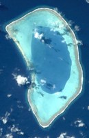
Beveridge Reef is a submerged atoll located in the Exclusive Economic Zone of Niue, approximately 130 miles (209 km) from Niue and 600 miles (966 km) from the Cook Islands. The reef is normally submerged, with only a small part visible at low tide. A useful and unique stopover for some cruising yachts on passage from the Cook Islands to Niue, the reef has claimed several fishing boats over the years, and now its first catamaran.
Published 8 years ago, updated 6 years ago


As reported by The Times – https://www.thetimes.co.uk
A veteran British yachtsman has described the terrifying moment his catamaran — with his wife and two sleeping children on board — ploughed into a remote mid-Pacific reef in the dark.
Bobby Cooper, 51, and his family were aboard their 50ft catamaran, Avanti, battling 40mph winds and high waves when the vessel smashed into Beveridge Reef, 150 miles from the tiny mid-Pacific island state of Niue.
“It was fairly interesting. We surfed onto the reef. Bit of a navigation error. It was very violent and we grounded. We were then being hit by subsequent waves as they came over us,” Mr. Cooper told The Times by satellite phone from another yacht that rescued them,
He said that their catamaran had hit the reef at 4 am on Monday morning while his children, Lauren, 13 and Robbie, 11, were sleeping.
Mr. Cooper said the catamaran’s GPS navigation system had not picked up the reef — a submerged atoll — that lay in their path.
He and his wife, Cheryl scrambled to get their children from their bunks and onto the craft’s deck.
“The waves were breaking over our stern. We got the kids up. We put them to the task of collecting whatever things they required and we assessed our situation” said Mr. Cooper, a highly experienced ocean sailor and captain who has made at least 15 Atlantic crossings on yachts.
“We realized the boat was not sinking and that the best place to be was on board. We sat it out until the waves pushed us far enough onto the reef to be away from the breakers,” he said.
The couple activated an emergency distress beacon that sent exact details of their location by satellite to New Zealand’s ocean marine rescue centre 1500 miles to the south.
New Zealand authorities immediately sent out emergency radio messages across the Pacific requesting that any craft near the stricken yacht go to the Avanti’s aid.
The message was picked by a 60ft New Zealand registered ketch, the Dona Catharina, which itself had suffered storm damage. Amazingly, the Dona Catharina was within two kilometres of the grounded Avanti. The New Zealand boat had taken shelter inside the submerged atoll while its crew — on route to assist a humpback whale research project near Niue — made repairs.
“They turned on their deck lights and we could see them, we communicated with them,” said Mr. Cooper. “If they hadn’t been there, we’d be sitting in a life raft right now, trying to keep warm and dry,” said Mr. Cooper.
Mr. Cooper, with the help of the Dona Catharina’s seven crew, has since managed to dislodge his family’s catamaran from the reef and anchor it in the calmer waters inside the lagoon at Beveridge Reef.
“The reef didn’t appear on our plotter, I’m afraid. It came as a complete surprise,” said Mr. Cooper.
Mr. Cooper is a well-known international yacht skipper who has captained the 75ft classic sailing yacht, Sirocco, once owned by the Hollywood star, Errol Flynn.
The family sold their house in Palma on the Spanish island of Majorca before setting out on a voyage to the Pacific in April.
The Dona Catharina was still sheltering from poor weather at Beveridge Reef earlier today and the family will stay aboard until she reaches Niue.
Related to following destinations: Cook Islands, Niue
Related to the following Cruising Resources: Off the Beaten Path, Pacific Crossing, Routing, Safety and Medical


Yes sad to read stories like this but I am very surprised that the skipper claims that “the reef was a complete surprise”. The reef is clearly marked on both electronic (navionics and cmap charts) and also on paper charts, even passage planning charts.
It is also well documented in sailing directions and pilots both printed and those available online.
I was on passage from Bora Bora to Tonga from Late August to early Sept so was close to this area.
In the same time frame and can vouch for the weather being bad but still, it is no excuse for lack of preparation of hazards along one chosen route. A case of bad seamanship I am afraid.
Chris SV Sea Bear
Hello,
it is always sad to hear stories like this. Luckily without casualties but a broken dream of a life.
Just a few days ago we returned home to Italy after a 3 years circumnavigation (www.circumnavigation-noe.blogspot.com). Luckily we never had bigger problems with the boat (Solaris 48) or with the navigation.
We used Navionics Gold and Platinum charts on our two Raymarine systems and paper charts. About 250 charts we had on board. A lot of people asked us why we spend so much money for old fashioned paper charts and not fully relying on the electronic staff which you can update every day.
The Beveridge Reef is charted on the Admiralty paper chart 4061 as a blue dot. This chart shows the entire western part of the South Pacific at a scale of 1:10’000’000. The reef is also chartered at Navionics but not at the correct position. Additionally, the electronic chart does not represent the reality of the submerged atoll with one pass which has a depth of about 7m. Also, the wreck of a fishing trawler is missing.
When we approached the reef in daylight with an overcast sky only the echoes from the radar gave us a hint where it is. From another sailor, we got the coordinates of the pass. If you don’t have the coordinates you should not enter and give the reef a wide berth.
What I don’t understand why experienced sailors don’t have at least the 6 paper charts on board you need to cover all oceans along the barefoot route. They are not helpful to approach islands but they give you a good overview where the dangerous obstacles are.
I have a print screen of the radar echoes, position of the reef at the Navionics chart and our way to the anchorage. I would like to share this picture if you send me an email to circumnavigation.noe@gmail.com. It is also nicely explained at Cruisers Wicki with a perfect chart.
Hans and Ursula / SV NOE
Sue,
Thanks for sharing this story with us. We are so glad the Coopers are okay! What good luck that Dona Catharina was so close by.
We are hunkered down in Bora Bora on the eastern edge of the rough weather Avanti experienced, preparing to sail in their same direction in a few days.
We noticed that the Beveridge Reef appears on our Furuno Chart, but only when it’s zoomed in to a map size of 35 nm across the screen (at 40 nm size it’s NOT visible).
Navionics and iNavx apps DO show Beverage Reef, but our Earthmate (Garmin) app, the map for our Delorme explorer device, does NOT show the reef.
Thanks for keeping us all well informed and maintaining the wonderful Noonsite, which has helped us out enormously in many corners of the globe.
Ellen & Rand, SV Golden Glow